Posts in Forest
A rainy day hike on the Tarawera Trail

Grey skies greeted us at Te Wairoa carpark. I knew we were in for a wet afternoon, but I was hopeful we would be closer to Hot Water Beach by then, and even planned a quick soak before catching the water taxi at 3pm. I’ve walked the Tarawera Trail twice before (from both directions) and was pretty confident with my five hour walking estimate. Unfortunately, there have been a couple of major storms since I last hiked the Tarawera Trail, and the large windfalls and overgrown sections did slow us down. I was still pretty close - it took us 5.5 hours and made it to Hot Water Beach with just three minutes to spare!

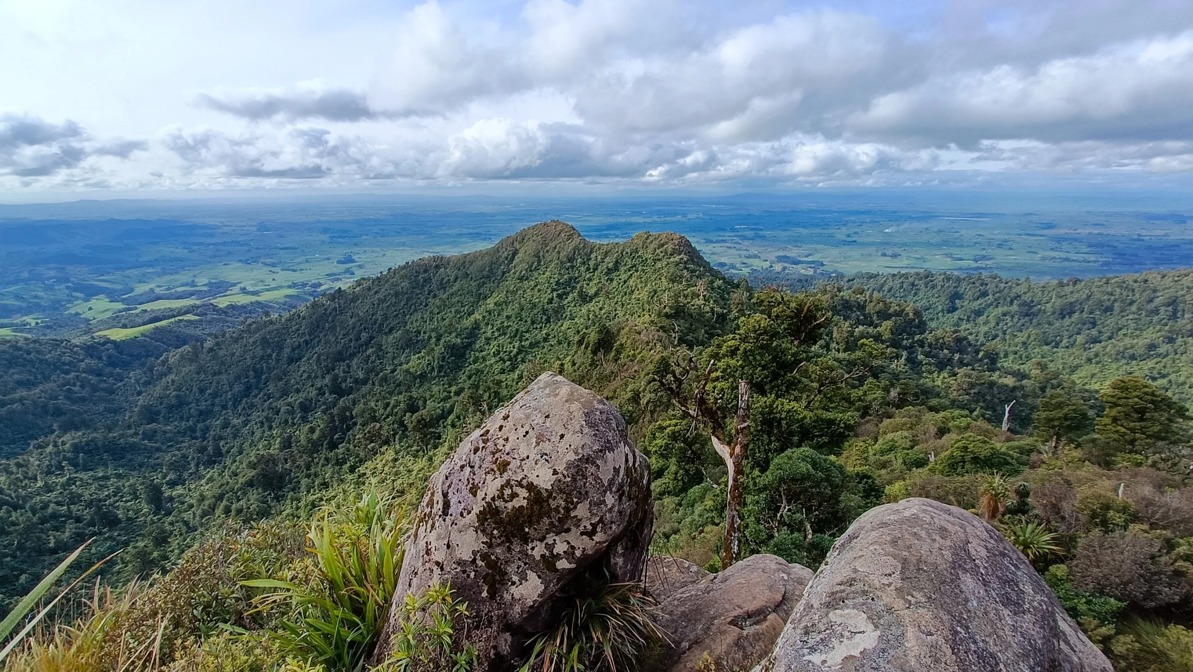
Even though it’s called the ‘Tarawera Trail’, I reckon it’s still a well marked track and beginners shouldn’t have too much trouble. When you leave the carpark, the trail will begin to narrow as it climbs up towards Te Wairoa viewpoint. There was a lot of grass and ferns growing over the track, which slowed me down a lot. Being just five feet fall, we had a good laugh as I bush bashed my way through, and the tall fella cruised through it. Is it even hiking in the backcountry without a bit of bush bashing?

Read More
Chasing waterfalls: Kaiate (Te Rerekawau) Falls and Ōmanawa Falls

Before 2023, the track down to Ōmanawa Falls had been closed to the public for many years. If you Googled ‘Ōmanawa Falls’, you would have found countless articles of people using sketchy trails, ropes and historic ladders just to get down to the waterfall. Millions of dollars have been spent on abandoned plans trying to make the old track safer and reopened. The new walking track officially reopened to the public in December 2023, with three viewing platforms and a gazillion stairs (just kidding, it’s only around 1,400 return). There’s no public access to the bottom of the waterfall and swimming isn’t allowed - it’s considered tapu/sacred by mana whenua, Ngāti Hangarau.

The walking track is 2km return, and 1.5 hours gave us plenty of time to enjoy the views and take photos. From the main car park, we walked along a gravel road to the Titoki Junction where we decided to head up the stairs instead of going to the first lookout (Te Tae Ōmanawa). We saved that one for last.

Read More
Pudding Basin Falls and Wednesday Falls

Walk in from the Ngamarama Track at the end of Whakamarama Road - look out for the DoC track sign to the right of the main car park. It's tucked away in the corner of the grassy area with the wooden picnic tables. There’s another entrance about 50m away, but there’s only room for one car there, so you're better off walking in from the main car park (it’s on your right as you are driving towards the car park). I actually walked in from the tiny car park as I didn’t see the sign the first time - this part of the track was narrow with long grass and gorse, but it eventually meets up with the main track after five minutes.

The forest section is a lovely, gentle downhill on a well-formed track. I reckon this was the last time my socks were dry. Here's the thing about hiking in the Kaimai-Mamaku Forest - you don't have to love walking in mud, you just have to be ok with it. Tall gaiters also come in handy in the tall grass on the way down to the waterfalls and the stream crossings. You will come across remnants of the old tramlines - even though the track itself isn’t too challenging as a hike, think about trying to transport giant milled Kauri back in the day. A lot of water pools between the tramlines, keeping the track wet and muddy for most of the year.

Read More
Tarawera Falls and Cascade Falls

 I still remember the first time we drove down that gravel road from Kawerau to Tarawera Falls. It was a family trip (I was still in high school) and I sat in the back, napping most of the way. Each time I woke up, all I could see was the dust rising towards the blue skies. It felt like forever! As an adult, it usually only takes us 30-40 mins from Kawerau. Each time I've taken friends there, they always wonder how something as magnificent could remain so relatively unknown. 

Tarawera Falls is accessed via a forestry road outside of Kawerau in the. Bay of Plenty. Even though I call it a gravel road, it's more like an unsealed road, and some sections are rougher than others. You don't need a 4WD, although if you have a lowered car, just be prepared for a slower drive. You will need to buy a permit ($10 per car) from the Kawerau isite - permits are only issued for weekends and public holidays. The isite is also close to New World, which is handy if you want to pick up last minute snacks.

The walk to Tarawera Falls from the carpark takes about 20 mins, and that's at a cruisy pace (with plenty of photo breaks). It's a well formed walking track, and I even saw someone on crutches the last time I was there. I wouldn't say it's pushchair friendly though.

Read More
Pahāutea Hut via Tirohanga and Maraukura Loop in the Pirongia Forest

Some adventures don’t always go to plan, and in the seven years I’ve been solo hiking, this one takes the cake! I had been on a road trip in the North Island performing poetry and had a few days up my sleeve in Hamilton before my next gig, so I decided to head to nearby Pirongia Forest. I parked up at the Grey Road car park (by the Pirongia Forest Lodge) with the intention of an overnighter to Pahāutea Hut via Tirohanga Track then walking out on the Maraukura Track the following day. If you want to do the loop, start on the Mangakara Nature Walk from the car park, then look out for the Ruapane Trig Lookout connection track. According to the DoC website, it’s easier to walk-in via Tirohanga Track, and I would have to agree with them.

Pahāutea Hut is about 30 minutes from the 959m Mt. Pirongia summit. Unfortunately there was thick fog at both times I went past, so I don’t have any photos of the views. It’s a 20-bunk bookable hut with several campsites nearby. There are multiple tracks that lead to the hut, so check out the DoC website for up-to-date track conditions. The terrain was often a challenging steep scramble, rooty with glorious thick mud that leads to incredible views (when the fog clears). Being in the middle of winter, the sooner you accept the bog, the quicker you’ll move past it.

There are chains on parts of the track (before and after the trig) - these definitely came in handy as the rocks were slippery from the rain. It took me back to my rock climbing days, and these short legs did have to tap into some short-girl-beta. If you’re a scrambler like me, take extra care that you don’t grab onto the pockets of gorse or cutty grass hiding in the bush - damn, that shizz hurts!

Read More
A winter roadie to Lake Rotopounamu and Waihāhā Hut

The first time I heard about Lake Rotopounamu was before my workmate went on maternity leave (she just came back to work a few months ago after a year off). I’ve driven past it a couple of times on my way to hikes in the Tongariro National Park, and I’m stoked that I tagged it onto my hike to Waihāhā Hut in the Pureora Forest.

Parking for Lake Rotopounamu is on Te Pononga Saddle Road (SH 47), about a 10 minute drive from Tūrangi. Look for the DoC sign across the road.

Lake Rotopounamu is said to be the heart centre of New Zealand, and I get it, listening to the abundant birdsong and walking amongst giants, time slows down. I’ve felt that in forests before, then again I love forests for that reason. What got me were the moments when the lake suddenly came into view. It takes you a few seconds to realise that the world isn’t upside down, but that the skies are so beautifully reflected on the water. 

The track is family-friendly - the loop is well marked and steady underfoot. It’s approx. 5km according to my watch. The track goes uphill in the beginning, but evens out after about 15 minutes. Most of the track is under a canopy, with plenty of lake access along the way. A section of the track is lakeside which was a nice break to walk in the sunshine before heading back into the forest. The loop took me around 1.5 hours, with plenty of time to enjoy the birdsong and take lots of photos.

Read More