Three day hike in the Waioeka: Moanui - Koranga Forks - Tawa Loop
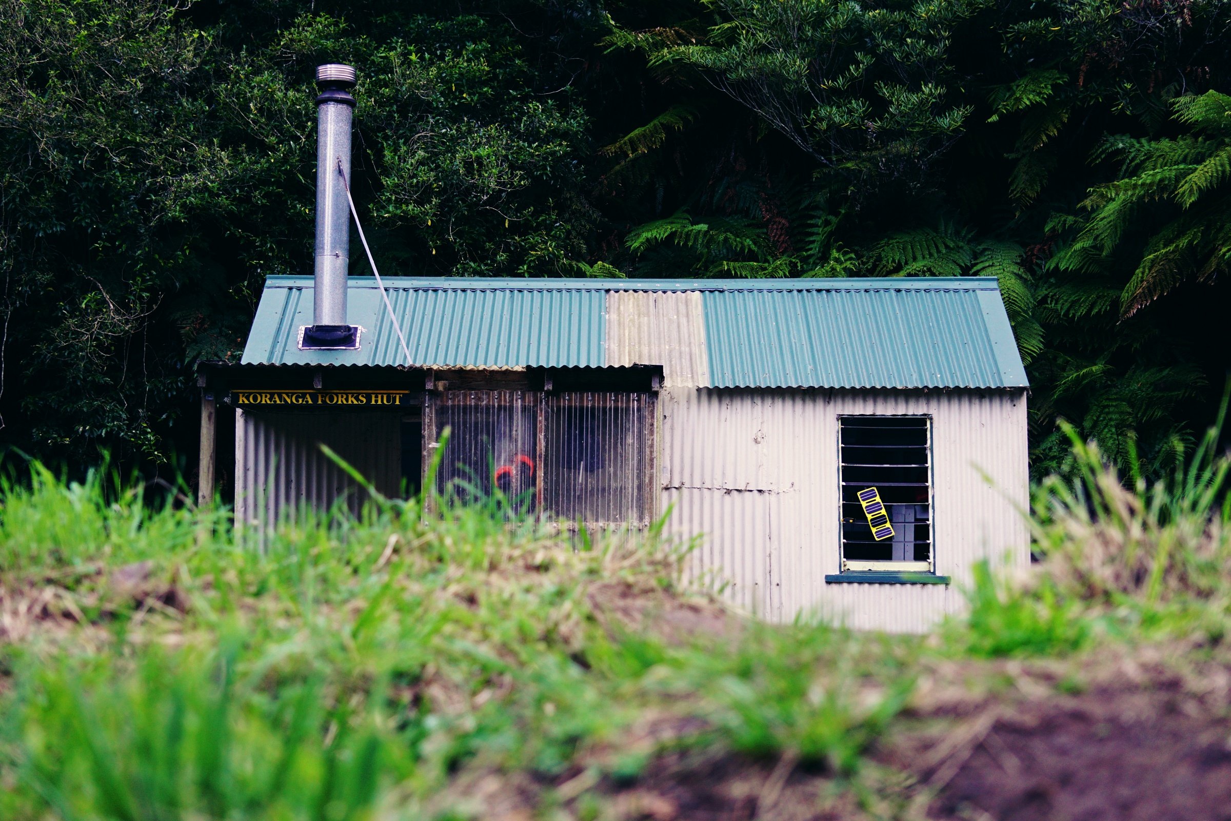
Koranga Forks Hut
Moanui carpark to Koranga Forks Hut: 9km, 4 hours
When you’re a townie like me, hiking in the backcountry always means driving a few hours. Usually down a gravel road with potholes, and the odd tree blocking the road. Moanui Road in the Waioeka Conservation Area had two out of three, luckily for me, it wasn’t a fallen tree because I don’t own a chainsaw yet. The carpark and start of the Moanui-Koranga Forks-Tawa Loop is about a 40 minute drive from Waioeka Gorge Road and then Te Wera Road turn-off. You can get through the gravel road on a 2WD drive, but the potholes can be pretty unforgiving to a low-riding bumper.

A couple of sheep gave me the side-eye as I walked through farmland.
I started my walk around 11am - fortunately it was overcast with a lovely breeze so I didn’t have to suffer the midday heat. The Moanui Track starts off on farmland as it follows the Koranga River. The bush sections are well graded and marked (orange triangles), while the open farmland had large, yellow wooden posts. Some sections narrowed down to double my boot width with steep drop offs, but as long as you watch your step, it’s fairly easy to get through. These are working farms, so keep your distance from livestock and leave gates as you find them (or follow instructions on signs).
As for the track, you can tell there had been a lot of clearing and maintenance recently. Shout out to the Department of Conservation team for all your hard work.
After a couple of hours in and out of the bush, I again popped out into farmland. The tracks climb up steadily along the rolling hills on a farm track. Following the pole markers, I made the mistake of trying to bum-slide down a pretty steep and sketchy track. I ended up dropping my pack and decided to find an easier way down. I had second-guessed myself and had actually seen the easier way down earlier. On the plus side, I did find an awesome patch of watercress when I dropped my pack.

Koranga River
There are no river crossings on the Moanui Track (some small streams, but not enough to get your socks wet), but expect to do a bit of boulder scrambling. The rocks were dry as I went through, but I can see it getting slippery in the wet. I met three hunters by the waterfall (the one with a barrier chain) on their way out after a couple of days in the bush. We had a good chat for about ten minutes as they rearranged their packs (they were walking out with a deer), and with the waterfall, it made a lovely spot to have a snack and catch my breath. After they left, I stayed a bit longer to enjoy the views.

The view of the swing bridge by Koranga Forks Hut
It took me four hours to get to the hut. After you cross the swing bridge, it’s five minutes to the hut. There were a couple of hunters napping when I arrived, and another having a wash by the river. Turned out they were from Whakatāne too. I didn’t feel the need to rush and claim my bunk - there were only four of us and Koranga Forks Hut is a 6-bunker. I walked down to the river (about a minute’s walk in front of the hut) to have a quick wash. The hunters left around 4pm for another hunt upriver, so after my cheese and crackers, I hopped up onto my bunk for the night for a well-earned nap. Dinner was rice and corned beef - it went down a treat in the chilly air.
The hunters came back around 7pm and after they put away their gear, one of them ended up lighting the fire. It made the hut nice and toasty!
Tawa Hut via Kahunui Stream: 13km, 7 hours

Tawa Hut on the morning of day three - with all three of us getting ready to head out
Sleeping on a top bunk has its downsides, including feeling the mental juggle of holding your pee for a few hours because it’s still dark outside. Someone’s alarm went off at 6am, there were a few groans but no one got up. All of a sudden my bladder threatened to unleash the Kraken unless I made the mad dash to the outdoor toilet.
The hunters said goodbye around 7am, heading out via the Moanui carpark. After porridge and coffee, I left the hut just after 8am, psyching myself for a long day of river walking.
Kahunui Stream is an unmarked route with several tributaries popular with hunters. You will pass many pest trapline markers (blue triangles), and unless you’re experienced in backcountry off-trail navigation, I suggest sticking to the river. Only attempt this section if there hasn’t been significant rainfall a few days beforehand. I’m 152cm tall (5ft) and there was some waist-deep water that I had to wade through in the last 3km before exiting the river and into the bush.

A pair of whio/blue duck in the Kahunui Stream
It wasn’t long before I saw my first whio/blue duck that morning - three flew upriver and then disappeared into the trees. Later on, I saw another pair near an island stream that I had to cross - I actually heard them before I saw them (their colouring gives them great camouflage!). So I dropped my pack, grabbed my Sony A600 (the only reason I took it with me) and while keeping my distance, lived my best Nat-Geo life.
Walking on river stones and multiple river crossings felt like a grind at times, but at least the water levels were mostly below my knees in the first three hours or so. Even in autumn, the water temperature was ok in shorts, but as I waded through deeper water late in the day, I did start to get cramps from the cold.
Around 2-3km before the river exit, I met the giant boulders. One thing I know about rivers with giant boulders is that there’lll always be deep pools to navigate. Most of the time I could scramble over them, but as it got later in the day, my short legs just didn’t have any power left. As I tried to get over a boulder with slippery footholds, I slipped and even whacked my hand on some ongaonga/stingle nettle. With fatigue setting in, I decided it was better to find another way through. It took me a bit longer, but at least I didn’t have to go for a swim either.
By 4pm I was absolutely starving! I didn’t know if I had another hour or two hours ahead of me, so I decided to have my noodles by the river. As I tucked into my hot noodles, a whio/blue duck flew right past me. In that split second of “Do I drop the noodles to grab my camera?” moment, I chose to tuck into my noodles.

A big smile spread across my face as I exited the river and saw this track sign
After leaving the river, I followed the bush track uphill for a few minutes, then it flattened out again. A great sense of relief washed over me as I knew the hut was only 40 minutes away. Those familiar orange triangles guided me all the way to the clearing where Tawa Hut stood. I unlocked the door to find the gear of a couple of hunters, which turned out to be Peter (dad) and Lucas (son) from Rotorua. They returned to the hut about an hour after I had arrived.
Peter and Lucas were cool hut mates - they had great banter, got the fire going, and even gave me some of their Struwen - which tasted like a cross between a pancake and a donut. I will definitely keep it in mind next time I’m out on a hike. It was dark outside long before my brain was ready to sleep, so I made sure to stay awake until 9pm. Unfortunately, my bladder decided a midnight dash was needed, but I did sleep longer than the previous night.
Tawa Hut to Moanui carpark: 10km, 5 hours

Great views of farmland from the top of ‘the burn’
I said goodbye to Peter and Lucas just before 8am. Even though I walked the track on my own, we would catch up with each other throughout the day. It turned out that we had even parked our cars next to each other.
The bush track on the way up to ‘the burn’ was mostly flat, I say mostly because there were a couple of track diversions that were real doozies. The first diversion felt more like a goat track and at times seemed steeper than 45 degrees. Times like these made me grateful that I only had my 40L and that I went up, not down. Peter and Lucas caught up to me as the diversion met the main track. It took me three hours to reach ‘the burn’.
What’s ‘the burn’? It’s a farmland track that meets up with the bush track. Affectionately called ‘the burn’ from the lactic burn searing your quads as you walk up the winding 4WD farm track. We were walking down, which can be more of a knee killer, but not as bad. The views from the top were incredible. Peter and Lucas dropped their packs by the track sign and went for a quick hunt. They even left me a note.
“We’re hunting 500m to the left. Just inside the forest. It is part of Waioeka Conservation Area there. Back at packs at about 12pm.”
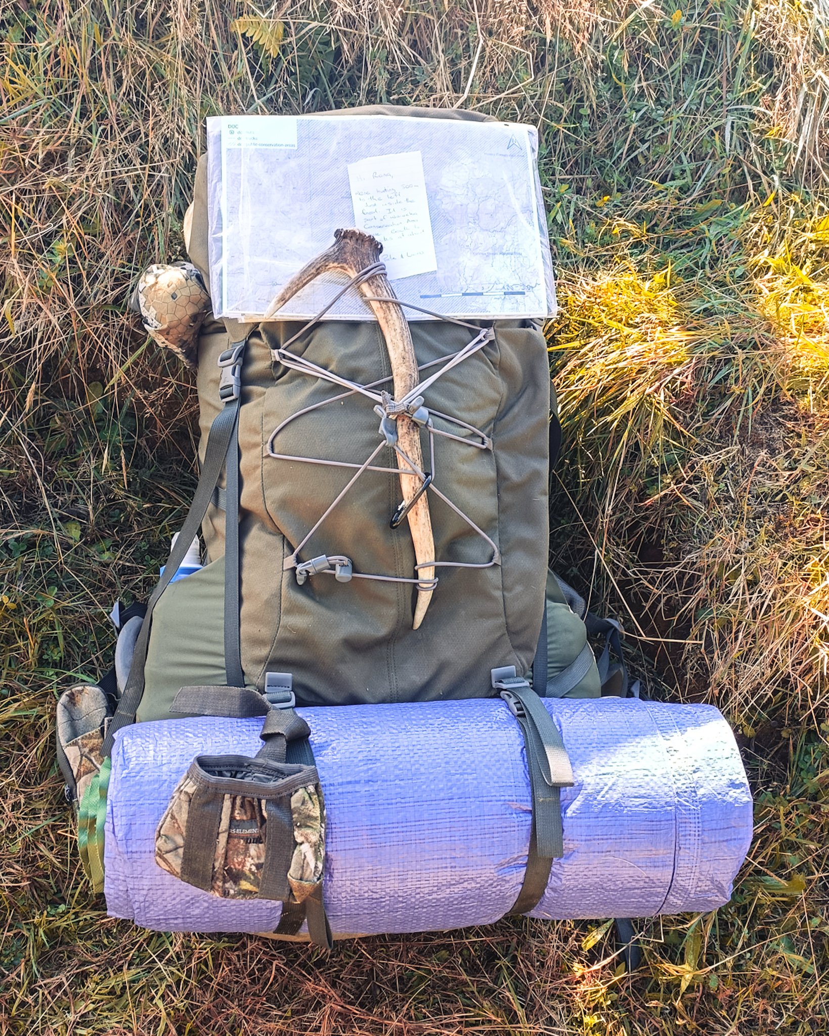
Peter and Lucas dropped their packs at the top of ‘the burn’ and left a note form me
It was a slow doddle down the farm track as I can be pretty clumsy when I’m tired. When I got down to the bottom, I somehow lost the track. I could see the yellow markers up the hill, so I just zig-zagged my way through the long grass until I found it again. The track wasn’t much more than a boot width in some parts.

Looking up at last swing bridge on the way back to the Moanui carpark
Oh but that last swing bridge really threw me. It started above my head, which meant I had to climb up a rock ledge. Not really that sketchy once you get up there. Peter and Lucas were about to cross the bridge just as I got to the other side. Peter climbed up the same way I did, so that was reassuring.
We passed each other a couple more times before we got to the carpark. Walking on my own, I guess they wanted to make sure I got out ok. Their car was parked next to mine, so we had a quick chat before they headed home.

Moanui Road
The drive back out of Moanui Road wasn't as daunting as I remembered. I pulled over once to let someone pass me (he gave me a quick wave), but for the most part, I was again on my own. I cranked up Matchbox 20 and enjoyed the drive home.
I stopped in Ōpōtiki for my walk out meal - it was supposed to be hot chips with garlic butter, but I got pizza and chicken wings from Pizza Plaza instead. The pizza was on point, but the wings were average. After my carbs coma, I took a quick nap before driving home to Whakatāne.
Do you want more information?
Check out the Department of Conservation’s website for more information on the loop track. The track distances on my Garmin were slightly more than on the guide, and of course, take your own backcountry experience and fitness into account when planning a hike.
Ronna Grace Funtelar is a 40-something desk-fit creative, weekend explorer and cheese enthusiast in Whakatāne, New Zealand. She has a big butt, chunky thighs and shakin’ more jelly than Destiny’s Child. Her creaky knees discovered an appreciation for Type 2 adventures in the bush and mountains in her thirties, and she’s been hiking ever since.
Liked this blog? CLICK HERE to donate a coffee today.